In 2019, Goldberg Resources conducted a comprehensive due diligence of the geological information collected by several companies that had previously visited the Caballos prospect. This review revealed compelling evidence of a copper porphyry system, particularly in the eastern portion of the property, east of the Pocuro Fault, where D-type veins—a key indicator of porphyry-style mineralization—were identified, pointing to priority targets for future exploration.
The Caballos prospect is located near the town of Putaendo and comprises approximately 16,000 hectares of mining concessions. These concessions are situated within the Miocene Metallogenic Belt, home to major mining projects such as Los Pelambres and Vizcachitas, which host significant copper and gold reserves—1,488 million tonnes of copper at Los Pelambres and over 3 million tonnes at Vizcachitas. The property is transected from north to south by the Pocuro Fault System (PFS), which likely served as a conduit for intrusive activity, giving rise to a hydrothermal system that enriched the area with various base metals.
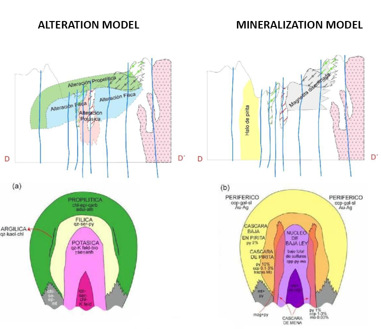
Between 2011 and 2013, several geological reconnaissance campaigns were carried out by different companies. These efforts revealed andesitic volcanic sequences that were folded and deformed by the PFS and intruded by multiple igneous bodies. Two intrusives are of particular interest: an alkaline intrusion in the northern sector, and a felsic intrusion with limonitic alteration to the northwest. In the central area of the prospect, quartz-sericite alteration and quartz veins mineralized with copper oxides were identified. The southern sector has emerged as the most promising for exploration, where tourmaline-associated alteration and outcropping breccia bodies were observed. It is also in this area where the D-type veins were found—characteristic features of copper porphyry systems.
Geophysical data further supports the mineral potential of the area. Magnetic and electrical surveys were carried out in 1998 by Quantec, followed by another electrical survey in 2006 by Zonge. The latter revealed strong chargeability responses at approximately 100 meters depth, suggesting the possible presence of sulfide mineralization.
Additionally, geochemical sampling campaigns were conducted in 2007 and 2011, collecting a total of 227 samples. These were analyzed and interpreted by Goldberg Resources with a focus on identifying anomalies in copper, sulfur, and arsenic, which could define exploration targets. The geochemical data was interpolated and processed using geostatistical methods, revealing anomalies aligned along the PFS from north to south—providing further support for the geological model proposed by Goldberg.